


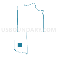
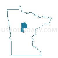
Meadowbrook Twp. Voting District, Cass County, Minnesota
About
Outline

Summary
| Unique Area Identifier | 601428 |
| Name | Meadowbrook Twp. Voting District |
| County | Cass County |
| State | Minnesota |
| Area (square miles) | 38.84 |
| Land Area (square miles) | 38.56 |
| Water Area (square miles) | 0.29 |
| % of Land Area | 99.26 |
| % of Water Area | 0.74 |
| Latitude of the Internal Point | 46.48952890 |
| Longtitude of the Internal Point | -94.56499150 |
Maps

Graphs
Select a template below for downloading or customizing gragh for Meadowbrook Twp. Voting District, Cass County, Minnesota


Neighbors
Neighoring Voting District (by Name) Neighboring Voting District on the Map
- Becker Twp. Voting District, Cass County, MN
- Byron Twp. Voting District, Cass County, MN
- Fairview Twp. Voting District, Cass County, MN
- Homebrook Twp. Voting District, Cass County, MN
- Maple Twp. Voting District, Cass County, MN
- May Twp. Voting District, Cass County, MN
- Moose Lake Twp. Voting District, Cass County, MN
- Poplar Twp. Voting District, Cass County, MN
Top 10 Neighboring County Subdivision (by Population) Neighboring County Subdivision on the Map
- May township, Cass County, MN (852)
- Fairview township, Cass County, MN (821)
- Becker township, Cass County, MN (517)
- Maple township, Cass County, MN (377)
- Home Brook township, Cass County, MN (255)
- Meadow Brook township, Cass County, MN (226)
- Poplar township, Cass County, MN (170)
- Byron township, Cass County, MN (144)
- Moose Lake township, Cass County, MN (111)
Top 10 Neighboring Unified School District (by Population) Neighboring Unified School District on the Map
- Staples-Motley School District, MN (10,060)
- Pine River-Backus Public School District, MN (7,315)
- Pillager Public School District, MN (5,216)